Dublin
 |
 |
A settlement was established in the area by the Gaels during or before the 7th century, followed by the Vikings. As the Kingdom of Dublin grew, it became Ireland's principal settlement by the 12th century Anglo-Norman invasion of Ireland. The city expanded rapidly from the 17th century and was briefly the second largest in the British Empire and sixth largest in Western Europe after the Acts of Union in 1800. Following independence in 1922, Dublin became the capital of the Irish Free State, renamed Ireland in 1937.
Dublin is a centre for education, arts and culture, administration and industry. , the city was listed by the Globalization and World Cities Research Network (GaWC) as a global city, with a ranking of "Alpha minus", which places it as one of the top thirty cities in the world.
The name Dublin derives from the Irish word Duibhlinn, early Classical Irish Dubhlind/Duibhlind, from dubh meaning "black, dark", and linn "pool", referring to a dark tidal pool. This tidal pool was located where the River Poddle entered the Liffey, on the site of the castle gardens at the rear of Dublin Castle. In Modern Irish the name is Duibhlinn, and Irish rhymes from County Dublin show that in Dublin Leinster Irish it was pronounced Duílinn. The original pronunciation is preserved in the names for the city in other languages such as Old English Difelin, Old Norse Dyflin, modern Icelandic Dyflinn and modern Manx Divlyn as well as Welsh Dulyn and Breton Dulenn. Other localities in Ireland also bear the name Duibhlinn, variously anglicised as Devlin, Divlin and Difflin. Historically, scribes using the Gaelic script wrote bh with a dot over the b, rendering Duḃlinn or Duiḃlinn. Those without knowledge of Irish omitted the dot, spelling the name as Dublin. Variations on the name are also found in traditionally Gaelic-speaking areas of Scotland (Gàidhealtachd, cognate with Irish Gaeltacht), such as An Linne Dhubh ("the black pool"), which is part of Loch Linnhe.
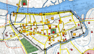
It is now thought that the Viking settlement was preceded by a Christian ecclesiastical settlement known as Duibhlinn, from which Dyflin took its name. Beginning in the 9th and 10th centuries, there were two settlements where the modern city stands. The Viking settlement of about 841, Dyflin, and a Gaelic settlement, Áth Cliath ("ford of hurdles") further up river, at the present-day Father Mathew Bridge (also known as Dublin Bridge), at the bottom of Church Street. Baile Átha Cliath, meaning "town of the hurdled ford", is the common name for the city in modern Irish. Áth Cliath is a place name referring to a fording point of the River Liffey near Father Mathew Bridge. Baile Átha Cliath was an early Christian monastery, believed to have been in the area of Aungier Street, currently occupied by Whitefriar Street Carmelite Church. There are other towns of the same name, such as Àth Cliath in East Ayrshire, Scotland, which is anglicised as Hurlford. The city is also referred to as Bleá Cliath and Blea Cliath in Irish, particularly when spoken. These are contracted versions of Baile Átha Cliath.
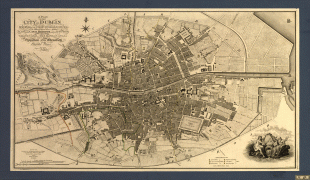
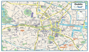
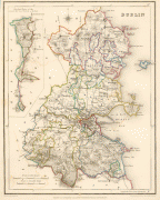
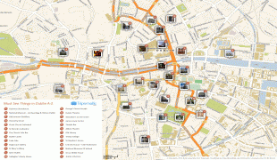
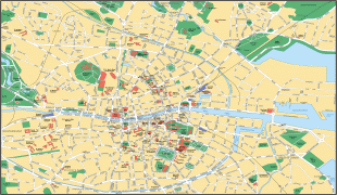
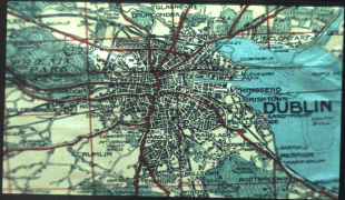
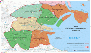
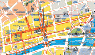
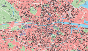
Map - Dublin
Map


Country - Ireland
 |
 |
| Flag of the Republic of Ireland | |
Geopolitically, Ireland is divided between the Republic of Ireland (officially named Ireland), an independent state covering five-sixths of the island, and Northern Ireland, which is part of the United Kingdom. As of 2022, the population of the entire island is just over 7 million, with 5.1 million living in the Republic of Ireland and 1.9 million in Northern Ireland, ranking it the second-most populous island in Europe after Great Britain.
Currency / Language
| ISO | Currency | Symbol | Significant figures |
|---|---|---|---|
| EUR | Euro | € | 2 |
| ISO | Language |
|---|---|
| EN | English language |
| GA | Irish language |